Please see the below weather update from the National Weather Service (NWS) New Orleans / Baton Rouge.
- The below watches/warnings will be in effect for East Baton Rouge Parish:
- Flood Advisory is in effect today from 2:49 PM through tonight at 7:00PM.
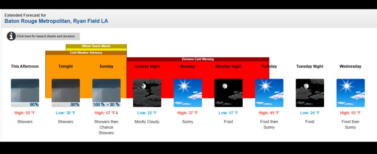
- Cold Weather Advisory in effect tonight beginning at 6:00 PM through Sunday night at 6:00 PM.
- Winter Storm Watch in effect at 12:00 AM Sunday through 6:00 PM Sunday.
- Extreme Cold Warning in effect beginning Sunday night at 6:00 PM through Monday at 12:00 PM.
- Today
- Periods of rain and a few storms will continue this afternoon/evening. Widespread 1”-2” of rainfall has fallen across the Parish with an additional 1”-2” of rainfall possible today.
- Highs near 55 degrees and low around 38 degrees for our area.
- There is no concern for frozen precipitation for our area today.
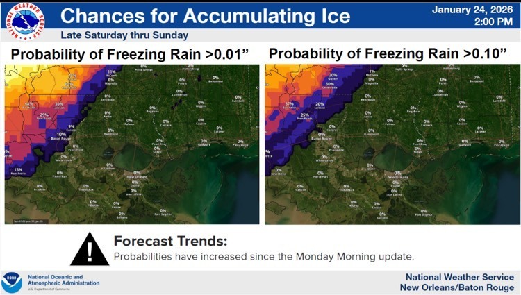
- Chances of accumulating ice continue to decrease for EBR with a 10% chance of less than a 0.01” of freezing rain Saturday through Sunday.
- Tomorrow
- More rainfall is forecasted for our area tomorrow with less than 1” of rainfall currently forecasted.
- Highs around 57 degrees with the temperature falling to around 35 degrees by 5:00PM.
- Sunday night mostly cloudy, with a low around 22 degrees. Wind chill values as low as 11.
- Monday
- Sunny, with a high near 37 degrees.
- Monday night widespread frost after 9:00 PM. Otherwise, mostly clear, with a low around 17 degrees.
- Monday 17 hours below freezing for EBR.
- Tuesday
- Widespread frost before 10:00 AM. Otherwise, sunny, with a high near 45 degrees.
- Tuesday night widespread frost after 8:00 PM. Otherwise, partly cloudy, with a low around 24 degrees.
- Tuesday 13 hours below freezing for EBR.
- Wednesday
- Widespread frost before 10:00 AM. Otherwise, sunny, with a high near 51 degrees.
- Wednesday night widespread frost, mainly after midnight. Otherwise, mostly clear, with a low around 29 degrees.
- Wednesday 9 hours below freezing for EBR.