- East Baton Rouge Parish is currently under the below watches/warnings:
- Cold Weather Advisory until Sunday night at 6:00 PM.
- Winter Weather Advisory until Sunday night at 6:00 PM.
- Extreme Cold Warning in effect beginning tonight at 6:00 PM until Tuesday at 12:00 PM.
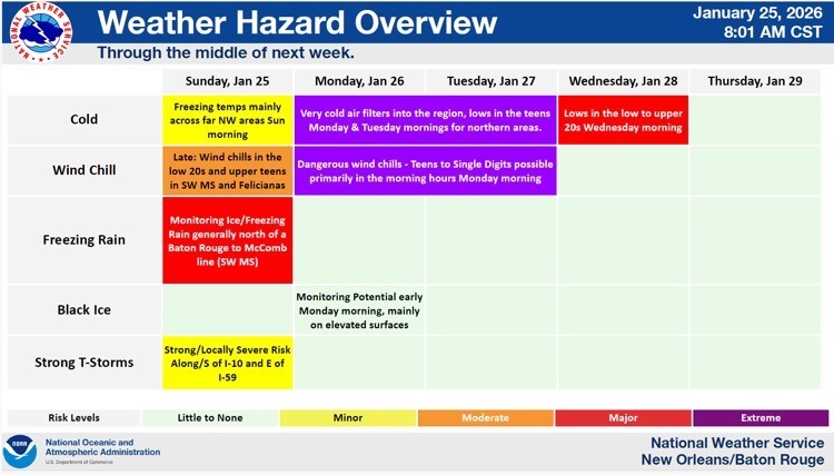
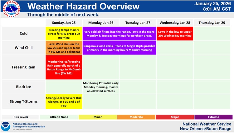
- Strong to severe thunderstorms will be possible ahead of the cold front this morning through this afternoon. Isolated pockets of sleet are possible. EBR is forecasted to receive less than 1” of rainfall with locally higher amount possible today until about 3:00PM. After 3:00PM, rainfall is forecasted to exit our area, and temperatures will begin to drop.
- Yesterday EBR received a widespread 2”-3”of rainfall across the Parish with some portions receiving higher amounts (3”-4” of rainfall).
- Overnight EBR is forecasted to dry out but there might be some slick spots on bridges.
- Monday through Wednesdayfrigid temperatures are forecasted for our area.
- Monday- Sunny, with a high near 40 degrees. Wind chill values as low as 11 degrees. Monday night widespread frost after 9:00 PM. Otherwise, mostly clear, with a low around 18 degrees.
- 17 hours below freezing on Monday.
- Tuesday - Widespread frost before 8:00AM. Otherwise, sunny, with a high near 47 degrees. Tuesday nightwidespread frost, mainly after 9:00 PM. Otherwise, partly cloudy, with a low around 23 degrees.
- 11 hours below freezing on Tuesday.
- Wednesday - Widespread frost, mainly before 9:00 AM. Otherwise, sunny, with a high near 51 degrees. Wednesday night widespread frost, mainly after 11:00 PM. Otherwise, mostly clear, with a low around 27 degrees.
- 9 hours below freezing on Wednesday.

Here is an update concerning the winter and severe weather threat today through Wednesday.
Changes from previous update:
· A Winter Weather Advisory was introduced for East/West Baton Rouge, Iberville, East Feliciana, and St. Helena Parishes as well as Pike County for this morning
Overview:
WHAT: Extreme Cold wind chills in the single digits to middle teens Monday and Tuesday morning & Freezing Rain accumulations up to 0.25 inches in Wilkinson County, and 0.1 inch in the advisory areas
WHEN: This morning for freezing rain and Monday & Tuesday morning for extreme cold
WHERE: Wilkinson County for the accumulations up to 0.25 inch, and areas along and west of I-55 for the minor accumulations (except for Livingston Parish)
CONFIDENCE:
· There is higher confidence in light ice accumulations across the warning and advisory areas this morning as the freezing line makes its way south
· Confidence remains high for Extreme Cold Monday and Tuesday morning
Impacts:
Freeze:
· Temperatures will fall into the upper teens and low 20s and will be below freezing for 10-20 hours for both Monday and Tuesday.
· These conditions could result in significant damage to unprotected pipes as well as citrus and other sensitive agricultural crops.
Wind Chill:
· Wind chills of 5 to 10 degrees are forecast for Monday morning and 10 to 20 degrees on Tuesday morning. These wind chills can lead to hypothermia for those without warm shelter.
Wintry Precip:
· Ice accumulation of up to 0.25 inch is forecast in Wilkinson County and up to 0.1 for areas west of I-55 except for Livingston Parish.
· Ice accumulation will be most likely on bridges and elevated surfaces, but even some surface roads could be affected (especially in Wilkinson County), resulting in treacherous travel conditions.
Severe Weather:
· A SLIGHT RISK of severe weather is forecasted for areas east of I-59, mainly for Sunday afternoon and evening ahead of the cold front
· Damaging wind and tornadoes are the primary threat at this time