Please see the below weather update from the National Weather Service (NWS) New Orleans / Baton Rouge.
- The rainfall has ended for our Parish and colder air is quickly moving in. Lows tonight will dip into the lowers 20s.
- East Baton Rouge Parish is under the following:
- Cold Weather Advisory until tonight at 6:00PM.
- Extreme Cold Warning beginning tonight at 6:00 PM until Tuesday at 12:00 PM.
- High confidence in impactful cold and wind chills tonight–Wednesday across most of southeast LA and southern MS.
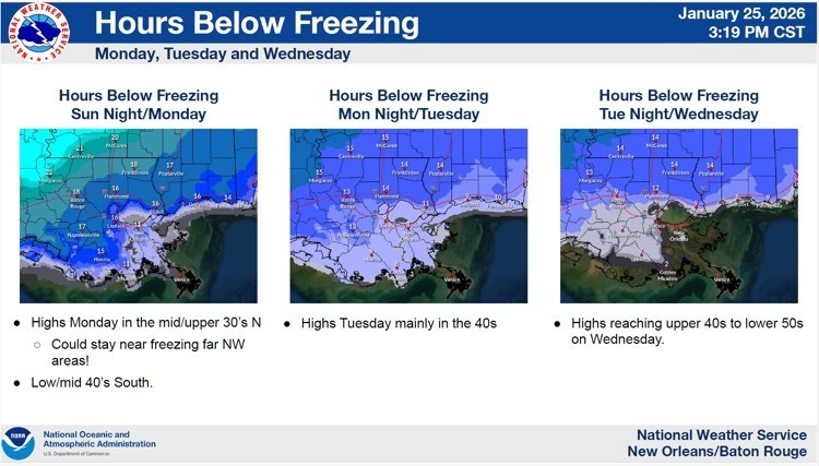
- Monday – Highs in the 30s and lows around 19 degrees. Wind chills in the teens. EBR below freezing for 18 hours Monday.
- Tuesday – Highs in the 40s and lows in the 20s. Wind chills in the teens. EBR below freezing for 13 hours Tuesday.
- Wednesday – Highs in the 50s and lows in the 20s. Wind chills in the 20s. EBR below freezing for 9 hours Wednesday.


Here is an update concerning the Cold threat tonight through Tuesday.
Changes from previous update:
- All Winter products have been cancelled
- Rain is quickly moving out
Overview:
WHAT: Extreme Cold wind chills in the single digits to middle teens Monday and Tuesday morning
WHEN: Monday & Tuesday morning
WHERE: Entire outlook area
CONFIDENCE:
· Confidence remains high for Extreme Cold Monday and Tuesday morning
Impacts:
Freeze:
· Temperatures will fall into the upper teens and low 20s and will be below freezing for 10-20 hours for both Monday and Tuesday.
· These conditions could result in significant damage to unprotected pipes as well as citrus and other sensitive agricultural crops.
Wind Chill:
· Wind chills of 5 to 10 degrees are forecast for Monday morning and 10 to 20 degrees on Tuesday morning. These wind chills can lead to hypothermia for those without warm shelter.