Please see the below weather update from the National Weather Service (NWS) New Orleans / Baton Rouge.
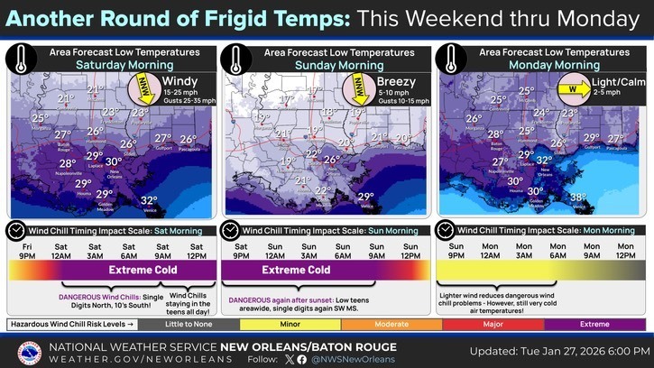
- A prolonged period of cold temperatures is expected again this weekend.
- An Extreme Cold Watch has been issued for East Baton Rouge Parish beginning midnight Friday night through 10:00 AM Sunday morning.
- Saturday night lows in the 20s with wind chill values around 15 degrees for EBR.
- Sunday night lows in the 20s with wind chill values around 16 degrees for EBR.


Here is an update concerning the cold weather threat on Saturday and Sunday mornings.
Changes from previous update:
- An Extreme Cold Watch has been issued for all of SE LA and S MS from midnight Friday night through 10am Sunday.
Overview:
WHAT: Extreme Cold with wind chills ranging from the single digits to the mid teens.
WHEN: From midnight Friday night through 10am Sunday morning
WHERE: All of SE LA and S MS
CONFIDENCE:
- We are confident that wind chills will fall into the single digits and teens Saturday and Sunday morning, though there is some uncertainty still with exactly how cold we will get.
Impacts:
Freeze/Hard Freeze:
- Temperatures will fall into the upper teens and mid 20s and will be below freezing for 5-20 hours on Saturday morning and10-17 hours on Sunday morning.
- These conditions could result in significant damage to unprotected pipes as well as citrus and other sensitive agricultural crops.
Wind Chill:
- Wind chills ranging from the single digits to middle teens are forecast and can lead to hypothermia for those without warm shelter.