Please see the below weather update from the National Weather Service (NWS) New Orleans / Baton Rouge.
- Prolonged period of cold temperatures is forecasted for our area this weekend.
- East Baton Rouge Parish will be under an Extreme Cold Warning beginning at midnight tonight through Sunday morning at 10:00 AM.
- Tonight - Mostly cloudy with lows in the 20s. Wind chill values in the teens.
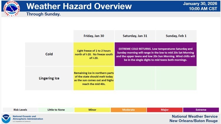
- Low temperatures Saturday and Sunday morning will range in the low to mid 20s. Wind chills will range in the mid-teens both mornings.


Changes from previous update:
· A Wind Advisory has been issued for New Orleans Metro to the coast as well as Slidell to Pascagoula early Saturday morning thru midnight.
Overview:
WHAT: Extreme Cold with wind chills ranging from the single digits to the mid teens; windy conditions south of Lake Pontchartrain.
WHEN: From midnight Friday night through 10am Sunday morning
WHERE: All of SE LA and S MS for the extreme cold; south of Lake Pontchartrain to MS coast for Wind Advisory
CONFIDENCE:
· We are confident that wind chills will fall into the single digits and teens Saturday and Sunday morning, though there is some uncertainty still with exactly how cold we will get.
Impacts:
Freeze/Hard Freeze:
· Temperatures will fall into the upper teens and mid 20s and will be below freezing many hours.
· Southwest MS and adjacent LA parishes will see 30-40 hours of consecutive sub-freezing temps
o The rest of the local area will only see temps above freezing for around 3-6 hours on Saturday.
· These conditions could result in significant damage to unprotected pipes as well as citrus and other sensitive agricultural crops.
Wind Chill:
· Wind chills ranging from the single digits to middle teens are forecast and can lead to hypothermia for those without warm shelter.