
Please see the below weather update from the National Weather Service (NWS) New Orleans / Baton Rouge.
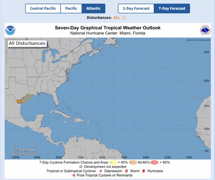
- The NWS National Hurricane Center continues to monitor Invest 90L which is expected to develop along the TX coast later today and move inland over TX/LA on Wednesday or Thursday.
- Invest 90L now has a 60% chance of tropical development over the next few days and a brief tropical system, could develop. Regardless of development, excessive rainfall and unsettled marine conditions are likely through Friday.
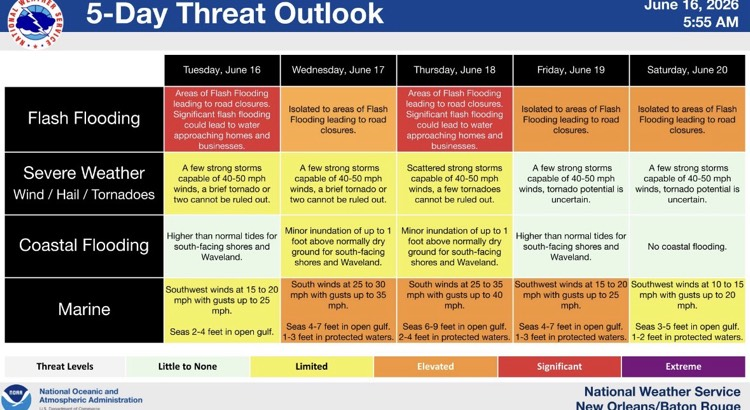
- East Baton Rouge Parish remains under a Flood Watch through Friday morning at 7:00 AM.
- The NWS is still forecasting multiple rounds of heavy rainfall each day this week. Rainfall totals of 4-6” with locally higher amounts possible for EBR through Friday.

Southeast Louisiana and Southern Mississippi partners -
Here is an update concerning the heavy rain threat this week as well as the tropical threat.
Changes from previous update:
- The threat of heavy rainfall/flash flooding has increased.
- The chance of brief tropical formation from the distrubance near the Mexico/Texas border has increased to 60%.
Overview:
WHAT: SLIGHT RISK to MODERATE RISK of Heavy Rain that could lead to flash flooding
WHEN: Multiple rounds of heavy rainfall will occur each day this week, but the heaviest rainfall is projected to occur on Thursday as a low pressure system moves through the state.
WHERE: All of Southeast Louisiana and Southern Mississippi.
CONFIDENCE: We are confident there will be multiple rounds of thunderstorms that will produce heavy rainfall in the area each day this week, but we have less confidence in exactly where these thunderstorms will develop and where the heaviest rainfall will occur each day.
Impacts:
- Rainfall of 4 to 6 inches is currently forecast through Friday. There is a medium chance of local amounts reaching 10 inches or more.
- There is a high chance that high rainfall rates of 2 to 5 inches per hour will result in several areas of flash flooding.
- As water drains into area rivers, there will be a threat of flooding along some rivers